Archive

Archive for June, 2009

TGOC2009: Day 4 – Cougie to Ft Augustus

June 28th, 2009 No comments

[Trail blog is here]

CIMG5319Today was a super long haul.   After leaving Cougie at 8am, we’d opted to take a easy but longer route up and over the ridge going by way of Hilton Lodge. This added 6km that was very easy going.   Today was one of the longer days taking 10 hours of hiking with short breaks.

Our feet really ached having banged out 31km to Ft Augustus.   It felt much longer too as the landscape was pretty boring compared to some of the great scenery of the past few days.  Interestingly we saw lots of Salamanders in mud pools at the summit above Ft Augustus.

As we got towards Fort Augustus, I started to dream about food.   I told Lynn I was thinking about Coconut buns and they looked so good I could almost smell them.   We later realized that Scotch Broom smells like coconut in full bloom.   Yum, it certainly made for an easier last few miles to Ft Augustus.

Old Drove Rd We were planning on camping tonight but were lured in by the delights of the local B&B.    We stayed at Caledonian Cottage B&B right above the locks which was a delightful little place serving a wonderful cooked breakfast the following morning.    We had a lovely pub dinner at the Loch Inn before jumping into bed for an early night.

CIMG5312CIMG5323

Today’s distance was a whopping 31km making 74km total.

On to day 5.

TGOC2009: Day 3 – Athnamulloch to Cougie Lodge

June 28th, 2009 No comments

[Trail blog is here]

CIMG5300 We woke up to find two blokes has pitched their tents in the barn!   After a nice breakfast of oatmeal and dressing Lynn’s developing blisters, we pushed on for Cougie Lodge.   This was an easy day for us with only 12km planned.

The walk out from Athnamulloch to Cougie follows the banks of Loch Affric which is in a stunningly beautiful location.   Unlike our prior days, the weather had finally cleared and were were experiencing full on sunshine with clear blue skies.   That’s more like it!

The path up from the Loch to Cougie was very muddy with soaking wet trails.   Looking at the map, it appears we missed a turn which is very odd since we were following a very well worn footpath with lots of boot prints in front of us.

After climbing for a while, we hit a ridge and then traversed along travelling through commercial forest which had been felled a while back.   We later learned they were replanting the forest for the native species and removing (I think) non-native spruce trees.

CIMG5301We arrived at Cougie before we knew it and were greeted with steaming cups of tea, scones, stew and chocolate biscuits.   I was on my second brew and in pops Hamish and crew.   Made for a fun hour before they headed out again.   We spent the afternoon just chilling out and doing laundry.   I have to say that it felt very decadent just waiting around but it was a great deal of fun interacting with the Cougie Kids and talking with Val’s nieces and nephews.

Cougie was the location of our first food drop but alas the UK “guaranteed 48 hr” parcel force service wasn’t having a good day.  I did wonder about the small print “rural areas of Scotland are not guaranteed” when we’d posted it three days prior.   It wasn’t too much of an issue since we’d be in Fort Augustus tomorrow and would be able to hit the shops for supplies.

By dinner time, a bunch of other challengers had appeared including Des Horan and Gordon Green.   A delightful pair of characters with whom we’d spend a great deal of time with in the coming days.  Gordon had a nice bottle of Scotch with him which he generously shared after dinner!!

After a nice dinner and shower we were tucked up in bed by 8am ready for an early 7:30am breakfast and the long 30km slot on to Fort Augustus.

Distance today: 12km making 43km total

Go on to day 4

TGOC2009: Day 2 – Falls of Glomach to Athnamulloch

June 28th, 2009 No comments

[Trail blog is here]

IMG_0007We woke up nice and early at 5am after a very cold night.   There was a lot of groundwater flowing underneath the tent so the floor acted like a fridge panel!

After a nice oatmeal breakfast, we packed up in the pouring rain and headed along the ridge following the river up to Loch Gaorsaic.   The going here was pretty hard with lots of peat hag jumping up and down.   We tried to find a better route by going high but it didn’t seem to make much difference.  We were headed for a set of stepping stones at the base of Loch Gaorsaic which would allow us to cross to the North side of the river.

When we got to the location of the stepping stones, there were only a few stones showing with the others a few inches below the surface of the river.    I’d had reports from a few weeks back telling me they were completely submerged so we were overjoyed to see the water levels had come down.   A quick change into our River Walkers and we were both across without any mishaps 🙂

From Loch Gaorsaic, we continued on towards the youth hostel at Allbeithe.   On the way we bumped into a group of four women (Fiona, Francis, Mary and Mari).   We’d actually met them the day previously and they’d taken a different route choosing to avoid the falls.    The youth hostel at Allbeithe was a welcome sight – by the time we arrived our feet were quite soaked and we welcomed steaming mugs of builder’s tea (tea, white with lots of sugar).

Crossing the Stepping Stones While in the youth hostel, we bumped into Hamish who asked us if we were the "Bloody Idiots" for camping on the ridge :-)    From the hostel, the walk to Athnamulloch was un-eventful, following a LRT all the way.    Athnamulloch is a random set of buildings which contain Strawberry Cottage, a very posh looking Scottish mountaineering house.

We met a guy staying in the cottage and he told us we were welcome to use the barn which was a wood store for the cottage.  We all pitched up tent in the shelter of the barn and then hopped inside to make dinner.    Mountain House spag bol for dinner which was great.    Francis gave us a packet of Apple and Custard dessert which tasted like heaven.

Distance today: 15km making 31km total

Go on to day 3

TGOC2009: Day 1 – Dornie to Falls of Glomach

June 28th, 2009 No comments

[Trail blog is here]

Day 1 of our 1st challenge was off to an interesting start.   The weather the prior day has been gale force winds (90 mph) with wicked rain.   We woke up early in the comfort of our hotel bed at the Lock Duich hotel.   The bedroom accommodation was good but the food and beverage service was poor.  Based on our stay there, I can’t recommend it.

IMG_0004
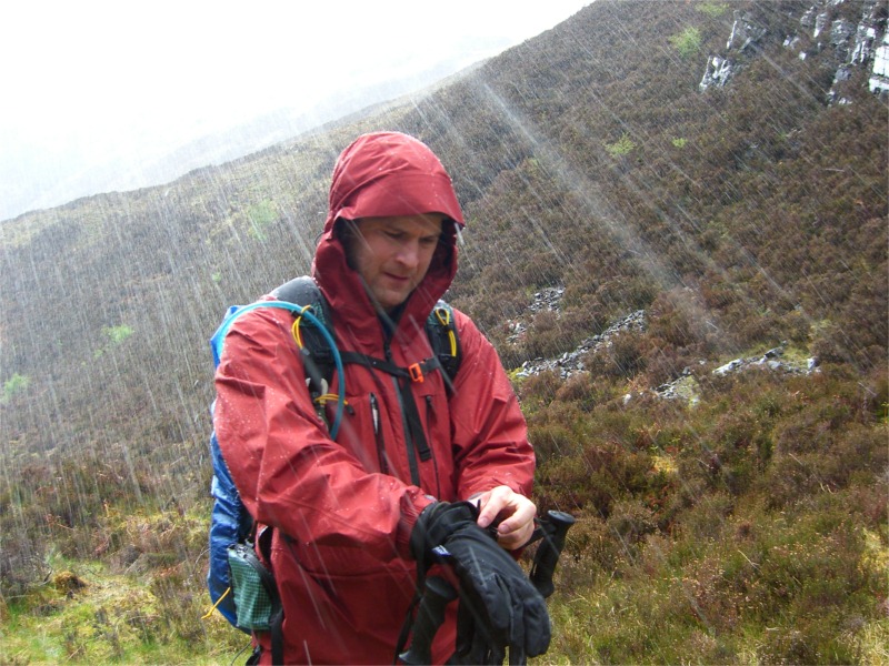
Today the weather had cleared a little and the rain had died off.  The winds were still gusting though with forecasts still showing 70mph winds dying off over the next two days.    Given the conditions we decided we would take our FWA (foul weather alternate) avoiding the high hills.

We left the hotel at the prescribed 9am sign-out time and paid one last visit to 914 Outdoor, a wonderful outdoor gear shop.   I’d had my eye on a hip flask that would prove to come in useful over the next few night camp.   I also found a really great headband/spam band that doubles as both a head cover and heck warmer.

A quick stop at the local post office / grocery for a small bottle of scotch and we were off!  We met of first challengers leaving our hotel since it was the official sign-out point.   Following the river up we bumped into almost a dozen including three days hikers and two “north to south” hikers who looked haggard, wet and were ready for a hot shower.  They’d been caught in the horrible weather of the past two days.

The hike from Dornie to the base of the Falls of Glomach wasn’t too eventful.  The paths were pretty easy to follow with little to see as you walked up the valley floor.    As were were cresting Camas-luinie the rain started again and quickly turned to heavy hail that was so painful we had to put on full weather gear including gloves. 

The base of the falls were pretty spectacular with amazing flow and noise – pretty much a full on waterfall that looked very cold.   We met our first river crossing here and had to cross a burn in full-on-spate.   Another solo challenger had been there for a while trying to decide whether to cross or not.    I popped on over without getting too wet.   Lynn opted to pull out her “dry walkers” and came over with a hand from me. 

We’d been told to be careful climbing up to the falls and were lucky that the weather cleared.  The trail near the top was very much a “goat scramble” that would have been very dangerous in driving wind and rain.   The view from the path to the actual falls was stunning and I’m ashamed to say we never got a picture.  In part this was due to the need to take an emergency bathroom visit 🙂

Our first night camping was pretty exciting – rather than camping on the valley floor which was extremely wet, we’d opted to take a little elevation and camped on what we though was a sheltered ridge (NH019245).   That was until the winds changed direction and gusted in a 2am causing the main guyline to let lose!

That wasn’t the only thing that went wrong; I’d neglected to remove my stove from the gas can and Lynn woke me up smelling gas.   After unscrewing it, gas was still flying out of the can causing it to go jetting around the tent!  Yikes – it appears the valve had failed so we had no option but to screw the stove back on and place it outside the tent.

Overall an exciting 1st day to our challenge.   We felt good and tired.

Distance today: 16km

Go on to day 2

TGOC2009: Trip Diary

June 28th, 2009 No comments

I finally completed the write-up of our 2009 TGO Challenge.    We blogged during the trip but missed out some of the more extensive notes.   I’ve collected them all here – the “Trail” links reference our on-the-trail blog entry while the “Diary” links to the more detailed report from memory and notebook.

My original post on our route with more details can be found here.  The actual route based on our SPOT navigator track is posted in a scrollable/zoomable map here.

# Route Distance Report
1 Dornie to Falls of Glomach 16km Diary|Trail
2 Falls of Glomach to Athnamulloch 15km (31km) Diary|Trail
3 Athnamulloch to Cougie Lodge 12km (43km) Diary|Trail
4 Cougie Lodge to Ft Augustus 31km (74km) Diary|Trail
5 Ft Augustus to Garva Bridge 25km (99km) Diary|Trail
6 Garva Bridge to Kingussie 30km (129km) Diary|Trail
7 Kingussie to Glenfreshie 21km (150km) Diary|Trail
8 Glenfreshie to Mar Lodge 23km (173km) Diary|Trail
9 Mar Lodge to Braemar 6km   (179km) Diary|Trail
10 Braemar to Shielin of Mark 27km (206km) Diary|Trail
11 Shielin of Mark to Tarfside 18km (224km) Diary|Trail
12 Tarfside to Edzell 20km (244km) Diary|Trail
13 Edzell to St Cyrus 18km (262km) Diary|Trail

All our photos are uploaded to SmugMug in the TGOC 2009 Album.   I’ve also posted “final thoughts” here.


Start reading here with Day 1: Dornie to Falls of Glomach.

Enjoy!

Thermarest Neoair

June 14th, 2009 3 comments

Lynn and I recently returned from our TGO challenge in Scotland.  One of the best pieces of kit we took was the new Thermarest Neoair mattress.    If you’re not familiar with it, Brett has a great “first impressions” review.

I took a Neoair “small” and Lynn took a Neoair “regular”.  They were very generously sized and extremely plush and comfortable.   The small comes in a 47” with the regular a whopping 72”!   I’ve included a comparison picture below.   

We really liked the Neo air for comfort during our trip.

Pros

  • Treated with non-slip compound which helps ensure you stay on the pad – I never slipped off at all.
  • Super light weight – 9oz for a 47” pad is amazing
  • Easy to inflate (the small is super fast though Lynn complains it takes her a while to inflate the regular)

Cons

  • Can be a little cold due to low “R” value (R2.5) – we found ourselves a little cold on some nights.   I would not recommend this mat alone for four season camping.    Thermarest recommends pairing it with the Z-lite pad which will add R2.2 making a very respectable R4.7 pad at only 19oz (size small).
  • Does not ship with a puncture kit – this is absolutely essential

Neoair head-to-headIn short I would highly recommend the Neoair to ultralight backpackers. Like most ultralight gear, there’s a tradeoff – with the Neoair, it’s with the R value; the comfort is very plush and much nicer than other mats I’ve slept on.  There was a lot of Neoair’s on the TGO challenge and almost everyone was raving about the sleep experience.    On sizing I find the small to be fine and stuff extra clothes/backpack under my feet to ensure they stay warm and elevated off the tent floor.  

Unless you’re fanatical about weight, you might consider the size medium which weighs in at 13oz but gives you a very generous 66” of length.  An alternate (which I’m thinking of doing) is to buy the Thermarest Neoair seat which is 10” x 20” (2.5oz).   This could easily double as a foot rest giving you an extra 10” to your Neoair small.   Plus you get a plush seat mat out of the deal too.

One nit is that the mattress does not ship with a puncture repair kit.  For an inflatable mattress, this should really come as standard.

Rating: Highly Recommended

Dehydrated Meals

June 8th, 2009 1 comment

On our recent TGO Challenge trip, Lynn and I ate our fair share of dehydrated meals.   We picked up most of our dehydrated food in the US (Backpackers Pantry, Mountain House, etc) and took it over with us.    During our trip, I was lucky enough to try two meals that we hadn’t had before, supplied by fellow Challengers Richard and Fiona.  The Mountain House Apple and Custard was wonderful at the end of a long wet day.   But the winner by a long stretch was the Chicken Tikka from Expedition Foods  UK.  This was enjoyed in the Scottish equivalent of the Brigadoon Bothy (Sheilin of Mark).   I was in absolute heaven!  Talk about tasty – nice and spicy too!  I felt as if I’d just run around to the local Indian takeaway.

This got me thinking – why not take some of my own home Thai cooking with me on the trail?  I already have a great dehydrator plus there are lots of great resources out there on how to dehydrate for backpacking.   Andy Howell has a great set of postings on his blog to get me started.

I’ll report back with my findings…

Free Online UK OS Mapping

June 6th, 2009 No comments

I recently found a wonderful site that provides a mashup of OS-GB maps alongside Google Satellite maps.   Where’s The Path has a bunch of useful tools for route planning, allowing you to import/export GPX track data.    It would be great to see this extended with footpath and walk information similar to the US site Red Trails.   Speaking of which, checkout our upcoming Wonderland Trail hike in Google Earth.   Stunning!

image

Lightweight Backpacking UK

June 6th, 2009 No comments

Andy Howell has a great post-TGO write-up on the state of lightweight backpacking in the UK.   During our TGO challenge, we saw many light weight backpackers who were coping well (even the Tarpers) with the extreme Scottish weather.   Go Lite!