Perhaps there is indeed hope for the wine drinking hiker after all. After Brett’s review of dehydrated wine:
“Clumpy, musty odor, like drinking beetroot juice spiked with cheap vodka that has spoiled at the bottom of the ocean for three hundred years.”
Alas, surely there must be something better? Enter the PlatyPreserve from our friends at Cascade Designs (the makers of Platypus):
Platypus employees claim to have kept wine in the PlatyPreserve for up to six months without noticeable taste degradation
Are the claims true? Does this really do the trick? Wunderbar! [sic]
Details available from http://www.platypreserve.com
 Just heard back from the TGO vetters (Ana and Alvar) that our route is go! They provided some really helpful advice on some of the trickier portions of the walk. Very impressive service – I hope to meet up with them in Montrose when we’re all done.
We now have most of the trip sorted including our flights from Seattle to Manchester, getting up to the TGO route start and back again, and have booked our a few “deluxe” overnight stays in a B&B’s as we go across Scotland :-). Our paper OS maps arrived today by Airmail from MapKiosk who appear to have the best online shipping and prices for OS maps.
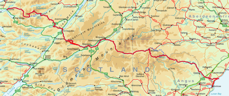
 I spent time over the holidays musing over the route for our planned crossing across Scotland as part of the RAB TGO Challenge in May. I’d previously purchased maps for Quo v2.0 which were extremely helpful in the planning process. Prior TGO trip diaries on the Phil’s Doodlecat TGO site and suggestions from Andy Howell’s post were invaluable.
Sadly, my plan of visiting several Whisky distilleries along the way didn’t pan out… Here’s the planned route (by day):
- Dornie to Falls of Glomach [Scottish Hill Tracks #266]
18km, 1300m ascent
- Falls of Glomach to Coire na Cloiche
FWA: Falls of Glomach to Athnamulloch Bothy via. Alltbeithe
20km, 1150m ascent
- Coire na Cloiche [Wild Camp] to Cougie Lodge B&B
FWA: Alltbeithe Bothy to Cougie Lodge
25km, 1300m ascent
- Cougie Lodge to Ft Augustus
27km, 700m ascent
- Ft Augustus to Garva Bridge via. Carrieyairack Pass
FWA: Avoid optional side-tour [2] at Corrieyairack Pass
28km, 400m ascent
- Garva Bridge to Kinguissie
30km, 500m ascent
- Kinguissie to Glenfreshie Lodge
16km, 500m ascent
- Glenfreshie Lodge to Forrest at Cairn Geldie
18km, 810m ascent
- Forrest at Cairn Geldie to Braemar
20km, 290m ascent
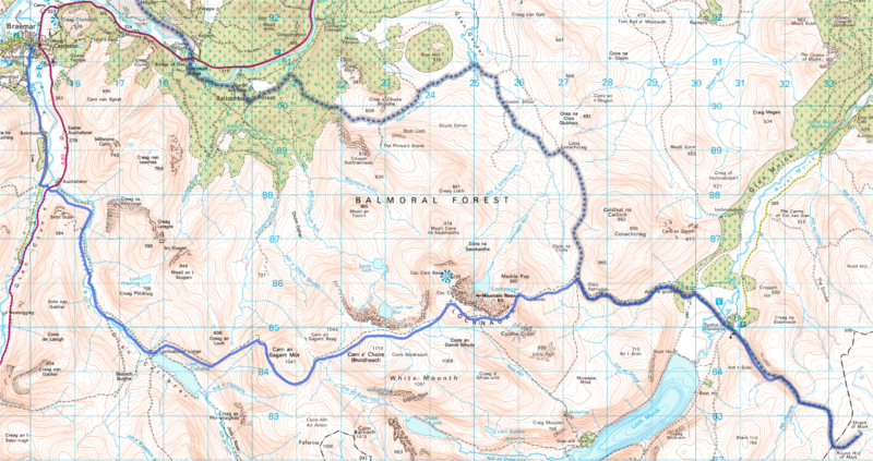
- Braemar to Shielin of Mark
FWA: Braemar to Shielin of Mark via.
30km, 2100m ascent
- Shielin of Mark to Tarfside
18km, 580m ascent
- Tarfside to North Water Bridge
25km, 220m ascent
- North Water Bridge to St Cyrus (then onto Montrose)
18km, 480m ascent
Total of 293km (183 miles) and 10330m ascent.
FWA == foul weather alternate.
Day 10 is a whopper of a day and passes over some very high terrain. Fingers crossed for great weather!
I’ve booked all our airline tickets from Seattle so we’re committed now. The focus over the next three months is going “ultra-light” – my strategy? Losing my “winter fat”… 🙂
Just got my mitts on a new ultralight backpacking jacket from the Outdoor Research Outlet in Seattle. The OR Celestial jacket weighing in at a nice 10oz should do the trick for our upcoming TGO Challenge hike in Scotland.

Hope may be at hand to make Brett’s Dehyrated Wine drinkable. Per a recent posting in the New Scientist, wine can be aged by passing lots of current through it.
I quote:
Pass an undrinkable, raw red wine between a set of high-voltage electrodes and it becomes pleasantly quaffable.
Alas, this still has the label "don’t try this at home kids" so we’ll be waiting a while…

I’ve been researching tent options for our upcoming TGO trip in May. I’d settled on the Lunar Duo from Six Moon’s designs after some in depth research on the BPL forums. I ordered it seam sealed with an extra Tyvec footprint. Should be here before Christmas in time for a dry run to see how it handles winter snow conditions from the safety of my yard.

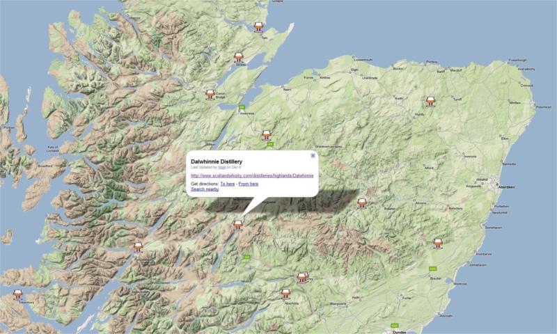
I’m in the process of planning our route across Scotland for the 2009 TGO challenge. I love Scotch and was hoping to drop in for “wee dram” in a few distilleries along the way. Alas, the only one that’s looking hopeful is Dalwhinnie.
Google Maps for your viewing pleasure here.
My copy of TGO Magazine just arrived courtesy of Zinio Reader. I won’t rant about how much I hate Zinio but it’s the only fast way to get overseas publications… Sigh…
This month is TGO month and the magazine includes a complete write up on the TGO challenge along with the 2009 entry form. A bunch of us are seriously considering taking on the challenge next year – it’s a coast-to-coast walk from East to West Scotland that has to be completed in under 14 days. It’s called “The Challenge” since each challenger or team has to completely plan their own route (with feedback provided on route choice).
For kicks, I plotted the official East Coast starting points on Live Maps to get a sense of the scale of the walk. Click on the map below for details. We have until early October to submit our entry forms.
Fingers crossed, it should be a lot of fun 🙂
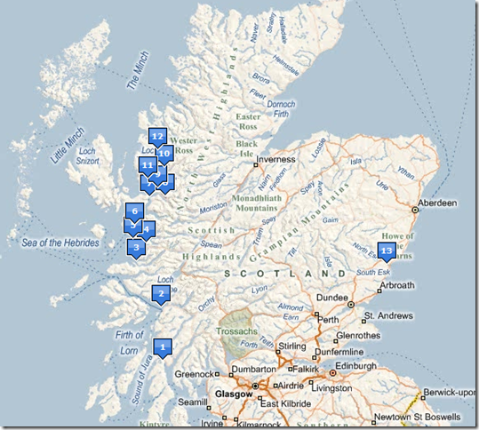
Update – Brett has posted an updated map here.
During my recent four day backpacking trip in the Pasayten Wilderness with Brett, Tim and Bill we visited an old Tungsten mine on Wolframite Mountain. The location is extremely remote (30 miles from Winthrop) so it was amazing to see the array of machinery present at the mine. While walking up the trail to the mine, we found lots of iron pipe which appears to have been used to supply the mine workers and machinery with water. I was astounded at the scale of the workings – everything on site (with the exception of wood) was hauled in via. pack trains taking many days to reach the location.
On returning to Redmond, I was curious to learn more about the mine.
Read more…
The campaign to save Turtleback mountain from development on Orcas Island has succeeded! Based on an amazing $18.5M fundraising effort, this beautiful mountain of 1600 acres is now part of the San Juan island landbank. This means it will be preserved as a public park with trails for all time. As of writing, the mountain just opened for public access starting hiking trails only. Longer terms there are plans to consider opening access for horses and mountain biking :-).
Details on the location and directions can be found at http://www.sjpt.org/pdf/driving_turtleback.pdf, a map is included below.


Recent Comments